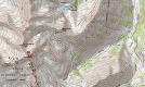
click images to enlarge
Coordinates (lat, long): 39.00976, -106.86131
Mileage (round trip): 7.0 mi (11.3 km)
Cumulative Elevation Gain: 3,100 ft (945 m)
Max Altitude: 14,265 ft (4,348 m)
Trailhead: Castle Creek Trailhead (39.02919, -106.80789)
Date(s) Hiked: 14-JUL-12
Duration (round trip): 7 hrs