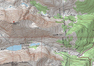
click images to enlarge
Coordinates (lat, long): 39.39722, -106.10648
Mileage (round trip): 7.0 mi (11.3 km)
Cumulative Elevation Gain: 3,400 ft (1,036 m)
Max Altitude: 14,265 ft (4,348 m)
Trailhead: Quandary Trailhead (39.38237, -106.06295)
Date(s) Hiked: 30-MAR-13
Duration (round trip): 5.5 hrs